Photo Essay: Sunrise in Shangri-La from the Summit of Pikey Peak
From Pikey Peak, travellers can see eight of Earth's ten tallest mountains in ideal conditions. | Photo: Matthew Nelson

Photo Essay: Sunrise in Shangri-La from the Summit of Pikey Peak

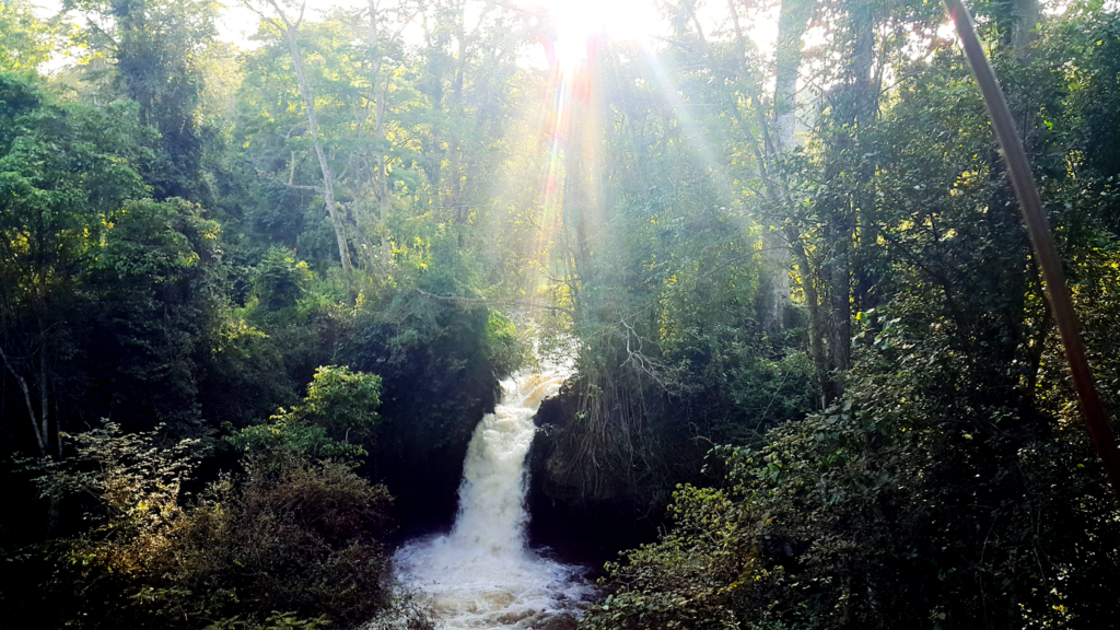
Nepal’s Pikey (pronounced “pee-kay”) Peak stands at an elevation of 4,065 metres. It is said to offer Sir Edmund Hillary’s favourite view of Mount Everest. 

Photographer Matthew Nelson visited the peak in December while scouting a new trekking route in the Solukhumbu region of Nepal called the Buddhism Sanctuary Trail. The eight-day trek is the perfect itinerary for those who desire to travel “off the beaten path” and avoid the congestion along the route to Everest Base Camp. Stunning Himalayan vistas abound, and the trail visits several noteworthy Tibetan Buddhist Monasteries. The trail is not for novice Himalayan visitors, however, as half of the stages require wilderness camping, where water can be difficult to find in winter. 

Despite the challenging terrain and cold temperatures, Nelson captured his story of the trek so others can more comfortably follow in his footsteps.

A second falling star burned out above me as I pushed myself onward in a howling wind toward the summit. Judging by the faint, twinkling lights of their headlamps, I could tell that the Sherpas were just a little bit behind me: Mingma, our guide, and our porters, Lakpa and Ongchu, who carried all of our food and cooking and camping gear for the nights spent in the wilds of the Himalayas. 

Even with all my layers on, the wind bit through to my bones, and I surged forward breathlessly up stone steps in the dark on a frosty morning. 

Peaky Peak
Arriving at our homestay accommodation | Matthew Nelson

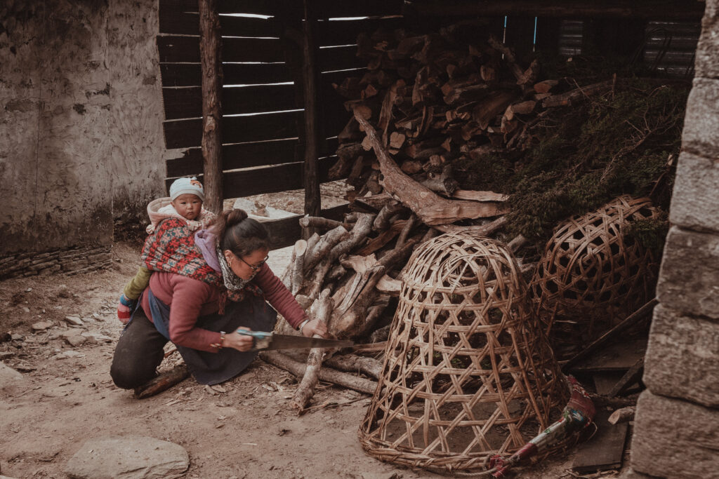
We had arrived at Pikey Base Camp in the late afternoon the day before and found a warm welcome at one of the two open homestays. A young woman was preparing our accommodation. She was joined by her beautiful little nani, who rode in the sling atop her back without complaint, legs kicking excitedly from time to time. 

As the temperature plummeted, we gathered closely around the wood-burning stove in a dimly lit common room and mingled with the family and the two Nepali guests who were the only other trekkers we met on our eight-day expedition. 

Sunset above a floating sea of clouds | Matthew Nelson

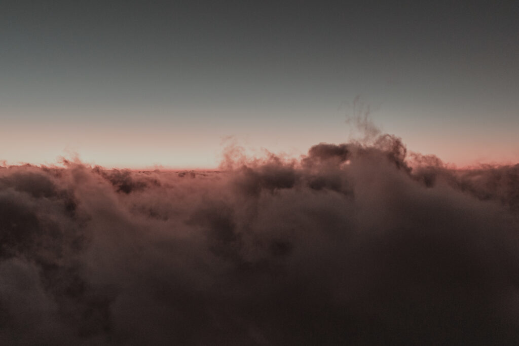
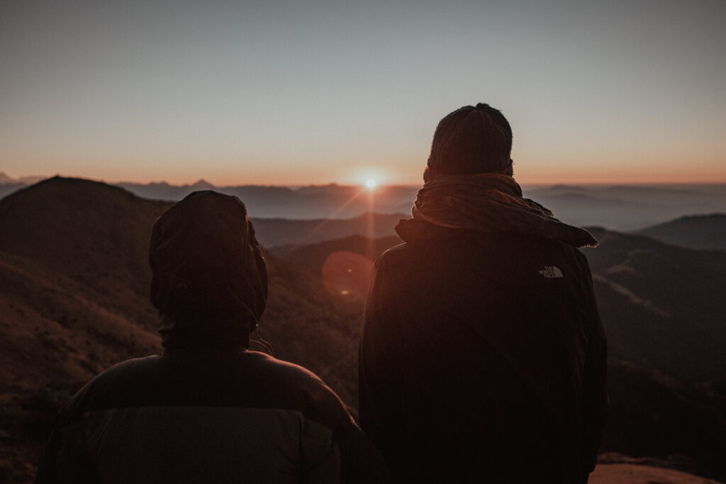
I braved the cold for as long as I could to capture the sunset as seen from our vantage point above a sea of clouds. After the exquisite golden light expired, I gladly went back inside to warm up and await our home-cooked meal. 

The next morning would begin with breakfast at 5:00 a.m., and an uphill climb in shivering winds lit by the light of falling stars.

Hundreds of prayer flags snapping in the wind | Matthew Nelson

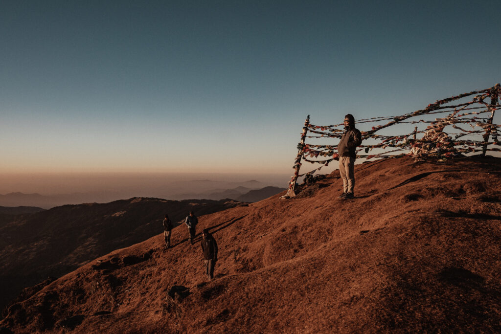
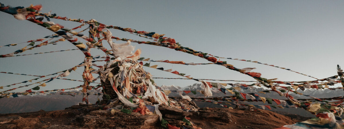
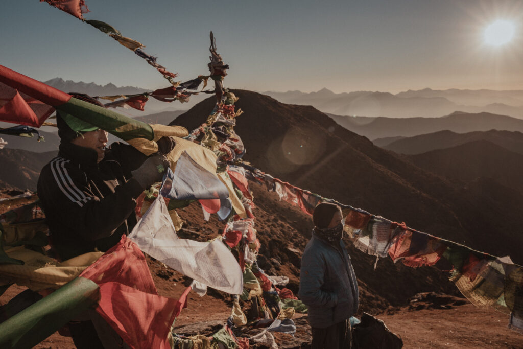
The sound of hundreds of prayer flags rippling fiercely in the wind signalled my arrival at the summit cairn. These multi-coloured hallmarks of Tibetan Buddhism were sending out prayers and peace on unforgiving winds to the far corners of Earth. Slowly, their colours materialised in the dawn as I was joined by the Sherpas and my friend and fellow Trail Angels scout, Kevin. 

Waiting for the sunrise together | Matthew Nelson

We set down our packs to await the sunrise from the only peak on Earth known to command a view of eight of Earth’s ten tallest mountains: Everest, Kanchenjunga, Lhotse, Makalu, Dhaulagiri, Cho Oyu, Manaslu, and Annapurna. 

As light flooded into the eastern sky, I removed my gloves and turned my camera on. The sheer cold of the ascent had completely frozen my freshly charged battery, so I reached into my pocket to find a warmer one to replace it and readied myself to photograph the sunrise. 

Counting the peaks in the early morning light | Matthew Nelson

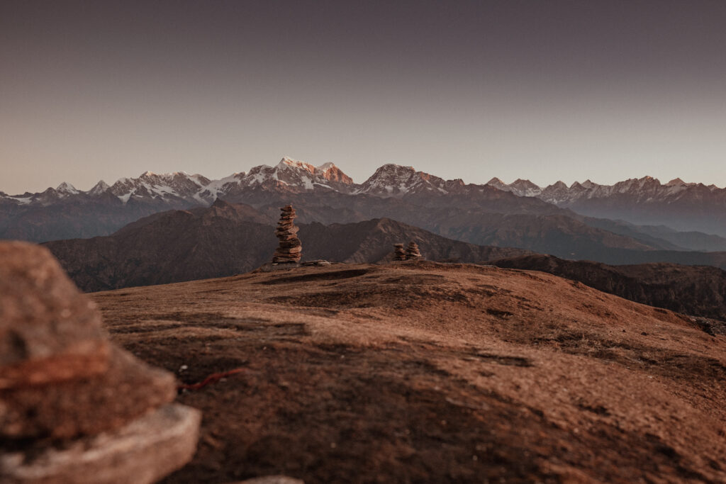
There was debate as we attempted to identify the peaks we could see. Everest and Makalu were identified easily based on their distinctive features, but the farther peaks were harder to discern. Dhaulagiri was some 300 kilometres away, after all. And was that actually Cho Oyu that we were seeing out beyond Numbur? 

This panorama shows the Numbur Himal range, with Everest, Lhotse, and Makalu visible (just barely) in the right third of the image. 

Stringing up prayer flags blessed by the 108 lamas at Boudhanath Stupa | Matthew Nelson

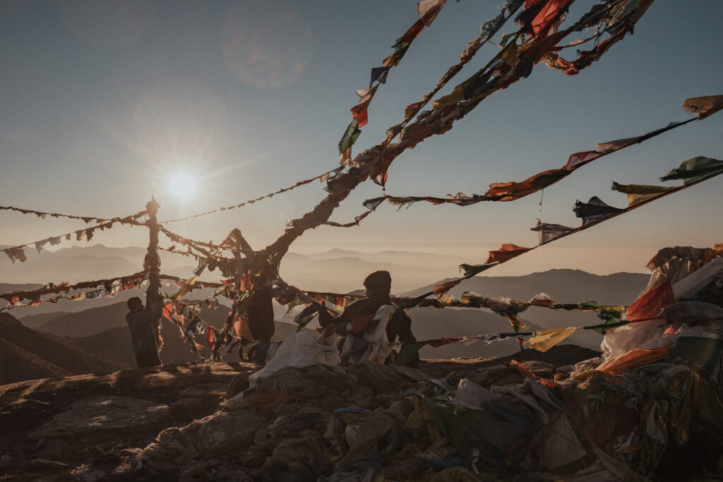
With no shelter from the biting winds, my previously full camera batteries died out one by one as I photographed my companions, who by now were focused on stringing up prayer flags blessed by the 108 lamas at Boudhanath Stupa in Kathmandu. 

As they battled the winds to secure these sacred strands in the newborn light, I started to lose all sensation in my fingertips. Letting go of my obligation as the expedition photographer, I surrendered to the elements, returned my camera to my pack, and buried my hands in my trousers as I joined my companions to silently take in the panorama before us. 

Mingma Sherpa balancing precariously on a pole to fix prayer flags in fierce winds | Matthew Nelson

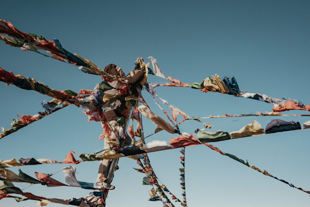
Mingma Sherpa, a veteran trekking guide and father of two boys, precariously climbed — and then balanced — on a pole jutting out from the summit cairn as he fixed our strands of prayer flags in fierce winds. Mingma hails from the village of Chaurikharka in the Solukhumbu region. While Mingma is native to the Solukhumbu, the specific trail we were scouting was new to him as well.

Lakpa Sherpa and Ongchu Sherpa, our indefatigable porters who hail from nearby villages | Matthew Nelson

Lakpa Sherpa (left) and Ongchu Sherpa (right) were our porters on this expedition, and hail from nearby villages. On top of bearing back-breaking loads along the trail (carrying our tents, food, and cooking gear), they set up and broke camp; secured water; cooked delicious meals; and brought us tea and coffee to warm us in our tents in the early mornings.

Kevin, my companion in scouting the Buddhism Sanctuary Trail | Matthew Nelson

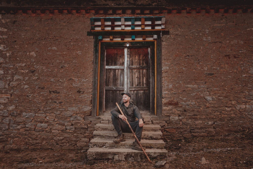
My companion in scouting the Buddhism Sanctuary Trail, Kevin, is a commercial fisherman from Nova Scotia, Canada. A veteran traveller of Nepal, he has visited the country nine times and spends a couple of months each year revisiting his favourite trekking routes. When not in Nepal, he enjoys months-long cycling tours through Asia and the Americas. 

This photo of him was taken at Taktor Monastery, where we concluded our day’s trek from Pikey Base Camp.  

Heading into the heart of Shangri-La | Matthew Nelson

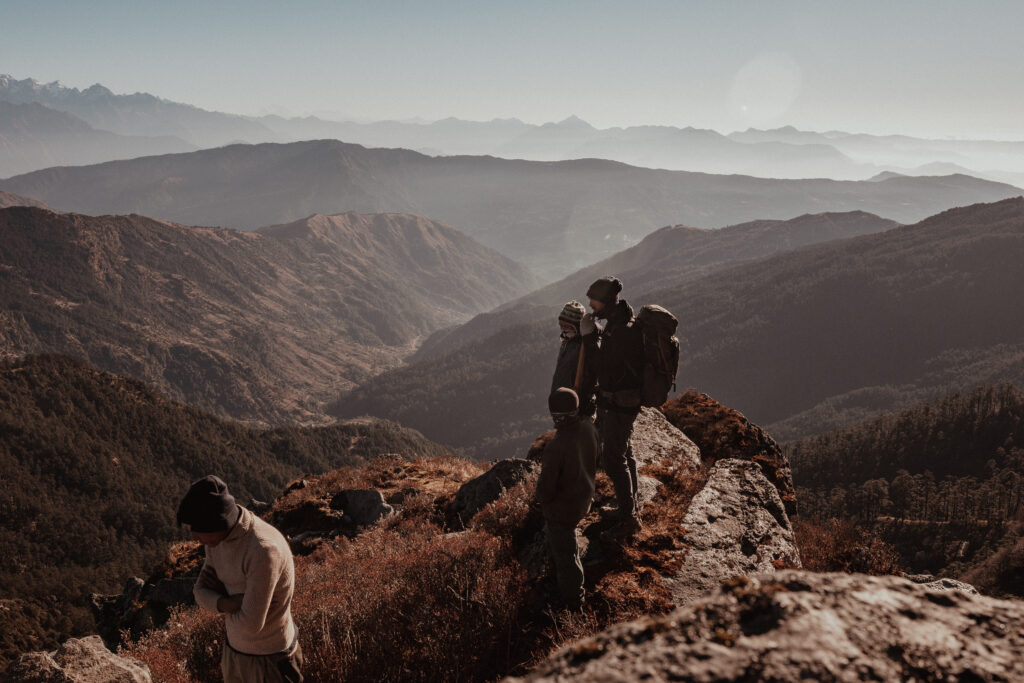
Setting our sights nearer at hand, we looked out across a gilded distance to try and glimpse a trace of our intended path ahead. We were headed for the sacred lake of Dudh Kunda and into the heart of Shangri-La. 

With our path now in view, we felt called to continue onward and shouldered our packs once again. We began our descent of Pikey Peak with the stars of our ascent traded for the remote warmth of a December sun.

Matthew Nelson

Traveller

Matthew Nelson is an American travel photographer and writer from Des Moines, Iowa. An advocate for sustainable travel, he has photographed responsible tourism initiatives in nine countries, notably in the Western Balkans, India, and Nepal, and is passionate about creating opportunities to travel with a positive impact to both the environment and local communities. His work has been published in National Geographic Traveller Magazine. You can follow his blog on transformational travel and find him on Instagram.

Time to Read:  5 Minutes
Traveller: Matthew Nelson
25 November 2022
Category:
Travellers' Tales - In this Moment - Photo Essay

Let Resonate Transport You!

Travel the world with the Resonate newsletter.

Highlights include:

  • Interesting stories from people in all corners of the globe
  • Vibrant photos sure to spark wanderlust
  • Ideas on where to go now — and how to do it responsibly
Meet Andre Saputra, the marine scientist championing coral restoration in Indonesia
Volunteer-driven Indonesia Biru Foundation is actively working to rehabilitate the coral reefs around Lombok, Indonesia. | Photo: Josh Edwards

Meet Andre Saputra, the marine scientist championing coral restoration in Indonesia

On a small Indonesian island, local volunteers are spearheading the fight to save their coral reefs — and help travellers participate in the work. Andre Saputra leads the effort.

“BCD? Check. Goggles? Check. Airflow? Check. Everyone ready?” 

On the surface, this looks like one of countless scuba dives happening every morning around the Gili islands in Lombok, Indonesia. It’s one of the most popular places for tourists to learn to dive given the low cost and overall beauty of the surrounding reef. 

But this isn’t just a fun dive. This group of divers have a mission.

For these divers, there is an existential dread with every dive: What if we lose all of this in the next 30 years? 

An organisation born out of lockdown

Andrean Saputra, or Andre, is a marine scientist and founder of Indonesia Biru Foundation (IBF), a local volunteer-driven non-governmental organisation. During 2020, Andre found himself in the same position as many other people around the world — tired and bored with the monotony of lockdown.

He decided he’d do something impactful with his time, taking up the fight for what he loves. IBF was founded with the aim of carrying out coral research, restoration, and coastal community development in several reefs around Lombok and the Gilis.

While quiet, the pandemic gave Saputra and his team the chance to restore reefs. Several sites were surveyed for suitability before teams constructed and planted “spiders” — large, metal structures that sink into the seabed, providing a canvas on which new coral can grow. The IBF team then harvested small pieces of coral from existing reefs, tying them to the spider structures. The rest was down to time and Mother Nature.

Above water in Kecinan Bay, Saputra and the team secured funding for the construction of a coral laboratory — a closed environment where the ocean’s conditions are replicated in tanks. It’s an important part of the jigsaw puzzle, where Saputra and the team study the resistance of different coral species in regard to rising ocean temperatures and acidity.

The coral lab is also an important place for locals, some coming into contact with the ocean for the first time. Throughout Lombok, many locals have a fear of the sea, so they have little to no understanding of why the ocean and corals are so important to their communities. As the harsh realities of lockdown highlighted so sharply, the local Lombok economy receives a huge injection of cash from tourists visiting reefs through diving tours, recreational fishing trips, hotels, restaurants, and other businesses based near these coastal ecosystems. If these were to disappear, thousands of livelihoods would be at risk, not to mention the additional impacts to agriculture and food chains.

Noise pollution, oil spills, and physical contact disturb the biota in the coral reefs.

Impact of tourism on the coral reefs

While tourism offers many advantages for local economies, it’s difficult to say the same for the surrounding reefs. Arriving in Indonesia by boat or plane, carbon emissions from international tourists are naturally a problem. The most pressing impact on the reefs are oil spills and noise pollution from boats that disturb the biota in the coral reefs. 

“The tourist activities themselves can be a problem,” Saputra explained. “When snorkelling and scuba diving, there are several things which aren’t done sustainably, like anchoring, stepping on corals, and touching the marine life.”

Many first-time divers come to Lombok to do their PADI certifications, resulting in bumping and knocking up against the corals. Imagine if one dive group of six people causes two incidents of coral damage. Then, consider how many dives are happening around Lombok and how many people are in the water each day. It’s easy to see how, over a number of years, the health of the coral deteriorates. 

During the pandemic the absence of crowds allowed nature the chance to breathe and reset. The coral reefs around Lombok saw a huge improvement. “There was no traffic, which meant that we could see in a few locations how biodiversity and fish biomass increased,” Saputra said.

What can tourists do to help?

IBF is now focusing on turning tourism into a beneficial tool for the reefs. The pandemic raised awareness about the importance of travelling responsibly and giving back whenever possible. Now, ocean enthusiasts visiting Lombok can enjoy diving while also getting involved in conservation. “If we really care about these marine habitats, then we have a moral duty and responsibility to give back.” said Josh Edwards, a British tourist involved with IBF. “If we carry on as we are, then these habitats will cease to exist in twenty years, destroying the reason so many visit in the first place.”

Tourists can plant corals and get involved in the maintenance and monitoring programmes. Even those who don’t want to dive can enjoy activities like beach cleanups, mangrove planting, or visiting the coral lab to learn about coral biology without ever getting wet.

“Being a responsible tourist is to actually make a place better than when you arrived,” Saputra said. “Lombok is a growing tourism destination in Indonesia, so we want to keep it as beautiful as possible, and one of the tools is to join conservation work.

Coral
Saputra is working with conscious tourists to maintain the marine habitat in Lombok.

The future of tourism in Lombok

Saputra is hoping for not only responsible travellers, but conscious travellers — those who care about the locals whose home and environment they visit. “If you try to learn about the history, the culture, and how people there live their lives, that will change your perspective on a place,” he said. “Hopefully, future tourism in Lombok will adopt this concept of quality tourism instead of mass tourism.”

A featured organisation on Restor for COP27, IBF is growing rapidly, and there’s a positive feeling among the team. “I hope that we can still enjoy the beauty of coral reefs, mangroves, and seagrass in the future, and not only in the next ten years,” Saputra said, smiling.

With tourism quickly returning to Lombok and the pandemic challenging everyone to think about the environmental impact of travel, joining local initiatives such as IBF creates a more meaningful, sustainable travel experience. 

Leyla Rose

Storyteller

Leyla Rose is a freelance writer and trained journalist based between the United Kingdom and Lombok, Indonesia. She has been freelancing since 2019 and specialises in writing about food, travel, and culture. Her work has been published in numerous magazines and online publications such as Fodor’s, Here Magazine, Culture Trip, and Matador Network, among others. She is also an avid and published photographer that goes hand-in-hand with her journalism. Find her work online.

Time to Read:  5 Minutes
Storyteller: Leyla Rose
25 November 2022
Category:
Game Changers

Let Resonate Transport You!

Travel the world with the Resonate newsletter.

Highlights include:

  • Interesting stories from people in all corners of the globe
  • Vibrant photos sure to spark wanderlust
  • Ideas on where to go now — and how to do it responsibly
Leafy Rainforests, Fresh Pawpaw Fruits, and Spirit Mountains in Embu, Kenya
Nthenge Njeru Falls in Embu, Kenya, is surrounded by forest. | Photo: Soila Kenya

Leafy Rainforests, Fresh Pawpaw Fruits, and Spirit Mountains in Embu, Kenya

Embu town springs up from the Embu-Nairobi Highway like a termite hill. A three-hour journey from Kenya’s capital Nairobi, it is the centre of Embu County, which is in Kenya’s eastern region, and has a mostly rural population. It is ideal for nature lovers who also want a local Kenyan town experience steeped in historical narratives that stretch back centuries.

The town is adjacent to Africa’s second tallest mountain, Mt. Kenya, and therefore enjoys a cool climate that matches perfectly with its rolling highlands and lowlands. Local expert Soila Kenya reveals the insider’s secrets of this often overlooked Kenyan getaway.

Embu, Kenya – On Arrival

Upon Arrival

After a visitor arrives in my town, I always recommend going straight to Izaak Walton Inn because it is the premier hotel in Embu. It provides a serene leafy environment with a swimming pool, sauna, gym, lounge, bar, and restaurant.

The best time to be here is December and January. That’s when the weather is relatively hot, making it much easier to explore some of the wetter rainforests that are otherwise quite muddy and waterlogged, which can make it difficult to trek through in the rainier seasons. It also provides better weather for those who would like to go swimming in the many waterfalls around the town. 

I tell first-time travellers to come with durable clothes and shoes for hiking. I also tell them to avoid littering because, as an agricultural town, there is a lot of greenery and outdoor space that should be preserved.

People from here know better than to frequent the really loud nightclubs in town at night. Newcomers are targeted by thieves and may be drugged and robbed. Instead, they would rather spend their evenings in their hotels, which have great activities, restaurants, and bars. 

A good historical sight to start your journey and get a good sense of this town is the Embu Scouts Camp, which is near the University of Embu. The founder of the global Scouts organisation, Sir Robert Baden-Powell, has a strong connection with Kenya and lived out a huge chunk of his life in the country. He is buried in Nyeri County, about a two-hour drive away from Embu County. 

Parents should take their kids to Izaak Walton Inn, Mountain Breeze Hotel, Panesic Hotel, or Royal Minni Inn because they all have swimming pools. This is an easy activity for kids to have fun during the sunny months while allowing their guardians a chance to eat and relax by the pool.

Food from the Heart

Among the food (or dishes) my town is most proud of, kirurio, a porridge popular among the Embu and Meru people, is an absolute must. I like to go to Chrismit Café to really enjoy it.

When we get together to celebrate, muratina is what people here traditionally drink. It has a distinctly mild sour taste with a pinch of sweetness. It is prepared by fermenting fruits from the “sausage tree” (named so because the fruits are sausage-shaped) in combination with sugarcane juice and honey. Because it is an unlicensed brew it is not openly sold, but once you are in town you can find your way to a seller by asking around. It is popular among not just the people of Embu, but the wider Central Kenya region residents like the Kikuyu.

When I eat completely local, I will go to Chrismit Café. I know the food here is great if you want a taste of the traditional foods in the area, like githeri (a mixture of maize/corn and beans).

Another three classic, iconic restaurants include Java, Simba Lounge, and Nile Perch. Simba Lounge also has a great bar, in case you find yourself there in the evening. 

The part of town where locals come for traditional food is the market in town. Obviously this is true if you have the opportunity to prepare your own food, in which case you can get all sorts of food stuffs like meat, vegetables, and fruits. If not, any of the restaurants mentioned above will do.

Embu, Kenya – Food from the Heart
Embu, Kenya – Shopping Locally

Shopping Locally

My town is notoriously known for farming muguka, which is the stimulant khat in English. Though the growth of this plant, whose leaves are chewed, has been a great windfall in terms of income for the families in the area (it sells much higher than traditionally grown food crops), the narcotic plant is being abused by men in the county and poses other concerns like reduced food crop output for Kenya as a whole.

The best outdoor food market in Embu is the market in the middle of the town centre. It is also where one can find everyday items like clothes.

It is also where I take visitors to buy real, local souvenirs like beaded jewellery and other items like kikoi, which is a traditional woven cloth, or kiondo, which are sisal bags. We know to keep an eye on our belongings as we trek through the market and to wear sturdy shoes that are durable against the mud of the rainy season.

Getting Deeper Into Embu

A great book to learn more about my town is “The Living History Embu and Mbeere” by H. S. K. Mwaniki from 1973. It captures a lot of the traditional culture, religion, and heritage of the region that have been disappearing with the onset of modernity.

Most people know about Embu, but Siakago town should also be visited because it provides a different look of Embu County. It is very dry and arid as opposed to the areas around Embu, which are more lush and green. You can also see the Thiba and Nyamindi Rivers.

My town is a place people are attracted to because of the many opportunities to go hiking and generally enjoy outdoor activities. There are several local hiking groups and companies that can facilitate your journey from Nairobi to one of the many hiking trails in Embu.

To really celebrate my town at its best, come during the sunny months because it’s easier to hike.

Most people think of my town as a place to stopover as you travel to other towns in Central Kenya, but really this is a destination that provides just as much diversity of things to do. Like the more popular Central Kenyan towns, it has the same offerings of mountains, forests, and wildlife to enjoy. 

This is one of the best places in the world to experience local Kenyan food. Locals are proud of that because Embu is a mainly agricultural town and prides itself on its mangoes and pawpaw fruits. The Mwea Irrigation Scheme is also in the county next door on your way to Embu and is a great place to buy local Kenyan rice.

Embu, Kenya – Getting Deeper
Embu, Kenya – Getting Around

Getting Around Embu

One thing you should know about getting around my town is that the public transport options are less obvious for a visitor who doesn’t already know how to get around. The two options are boda bodas, which are motorcycles that can take you to an exact location for a fee, or matatus, which are 14-seater minivans that have designated drop-off and pick-up areas and are therefore less flexible but cheaper.

The best way to travel in my town to have as little impact as possible is with a personal vehicle. 

Luckily this method of transportation also allows me to travel outside of the town centre much more easily and have control over my itinerary when travelling early in the morning or late at night, especially due to security concerns when it is dark.

Outside the Town

To get away and into the outdoors, I like to got to Kîrîmîri Forest. It’s great for a day hike and starts at the beautiful Nthenge Njeru Waterfalls. 

For a day trip just beyond my town, I like to visit Mwea National Reserve. It is a nature reserve maintained and protected by the Kenya Wildlife Service. It has a savannah ecosystem and is mostly known for its wide range of wildlife attractions that include elephants, giraffes, zebras, lesser kudu, buffalo, bucks, impala, monkeys, aardvarks, baboons, and many other animals. However, there are no wildcats at the reserve.

Many people will head to Nthenge Njeru Waterfall, but locals know to go to Ndunda Waterfall in the Njukiri Forest, where you can enjoy hiking and nature walks, a canopy walk, and ziplining.

I really enjoy the view of my town from Karue Hill.

Embu, Kenya – Outside the Town
Embu, Kenya – Connecting with Locals

Connecting with Locals

When I want to have fun and celebrate being out in my town, I go to the market in town. Speaking with the sellers there as you do some window shopping is always interesting, as you learn about the things that bother them in their daily life. 

To hang out with my friends and go to a real insider spot, I go to Nile Perch, where I enjoy their good food.

The best resource for finding out what’s going on around town is word of mouth. As you visit different restaurants and hotels, always ask the wait staff for recommendations on events taking place during your stay.  

When I want to enjoy my town without spending much (or any) money, I go on a walk through the University of Embu campus, which has large tracts of forest with five dams hidden within.

Simba Lounge is my first choice for music because it has a great vibe. It is a local spot where you can also dance.

Finding Solitude in Embu

When I want to go somewhere to sit and meditate about my incredible town, I go to Karue Hill, which is about a 30-minute drive outside Embu. Lying at 1600 metres above sea level, it provides a relatively short hike. Because of the arrangement of the prehistoric rock formations, there are natural “seats” that are ideal for some relaxing time, either alone or with a companion. Locals find it great as a romantic spot for lovers. Embu people associate these grand natural phenomena (waterfalls and high places like hills and mountains) with the presence of God and some come here specifically for a more spiritual experience.

If I chose the one place that makes me most proud of my town, it would have to be the Seven Forks Hydro Stations because it consists of seven dams that were built along the lower part of Tana River. The five dams that make up the scheme (Masinga Power Station, Gitaru Power Station, Kamburu Power Station, Kindaruma Power Station, and the Kiambere Power Station) are responsible for much of the electricity used in the country and contribute to making Kenya one of the world’s leaders in renewable energy use.

Kenya
Embu, Kenya – Finding Solitude
Embu, Kenya – When the Seasons Change

When the Seasons Change, The Town Shines

As Kenya lies squarely at the equator, we do not experience the four seasons, but rather periods of heavy rains, short rains, and sunny months. 

I always recommend people visit in the sunny months (December to January) because they have time off work during the Christmas holiday and New Year’s and can enjoy trekking through the usually soggy and muddy rainforests with less hassle. It will also be easier to enjoy the many waterfalls, in case you want to take a dip in nature.

The colder months (July to August) here are magical because of the fog and chilly fresh air. As the town is close to Kenya’s tallest mountain, Mt. Kenya, it receives a fair amount of rainfall, so the outdoors are filled with so much greenery that thrives during these months.

Soila Kenya

Local Expert

Soila Kenya is an award-winning data journalist, content creator and communications specialist from Kenya. She enjoys writing about women's health, science, environment, travel, career advice, tech and internet, and pop culture. She has written for Quartz Africa, Poynter Institute, The Org, The Continent, openDemocracy, The Star Kenya, Debunk Media, and Inspire Afrika. Find her work at soilakenya.com.

Time to Read:  9 Minutes
Local Expert: Soila Kenya
25 November 2022
Category:
Destination Guide

Let Resonate Transport You!

Travel the world with the Resonate newsletter.

Highlights include:

  • Interesting stories from people in all corners of the globe
  • Vibrant photos sure to spark wanderlust
  • Ideas on where to go now — and how to do it responsibly
Orange for Friendship: My Month of Learning the Language of Maasai Beads
The Maasai are one of the most revered tribes in Africa for their nomadic lifestyle, signature dress, and beads. | Photo: Ian Macharia on Unsplash

Orange for Friendship: My Month of Learning the Language of Maasai Beads

Over boisterous conversations and lots of laughing, Maasai women taught Mwende Mutuli Musau about the traditions and meanings of the tribe’s rich bead-making culture.

One chilly morning in the midst of Kenya’s cold season, I packed my belongings in a big backpack, said goodbye to my family, and headed out for a month of volunteer work with AIESEC, a non-governmental student organisation. I was 19 years old as the van began its long, bumpy journey away from the comfortable urban lifestyle I was accustomed to in Nairobi.

Our destination? The Maasai Mara, one of the most revered national parks in Kenya and home to the Great Migration, one of the seven wonders of the world. 

And, it turns out, a rich storytelling culture embedded in beads.

In a couple of hours, the city was long behind us and we were surrounded by thickets of bush and the sound of wild animals. Our group was greeted by tall women with warm smiles wearing red shukas (traditional shawls) and adorned in beautiful beads from head to toe.

The village was simple with several manyattas (traditional huts). Children were laughing and playing, elders were gathered around a fire, and women were cooking. It felt blissful and calm.

I was still soaking in the scene when a young moran (warrior) approached our group of five volunteers —: two women and three men — and separated us by gender. The other female volunteer and I were guided to a manyatta, our new living area. Then we settled around a bonfire, had dinner, and familiarised ourselves with traditional Maasai customs.

The morans gathered together, laughing and drinking cows’ blood. Afterward, they began chanting and jumping, which was a show of masculinity. I was transfixed by their red hair blazing in the night bonfire and their beautiful beads. It was impossible not to stare; they oozed with elegance and grace, so unapologetic and bold in their culture.

The following day, we were assigned chores. For the duration of my stay, I had to walk 7 kilometres twice a week with the rest of the young women to fetch water in the river, do household chores like cooking and cleaning, and, most importantly, learn how to make beads.

The Maasai are one of the most revered tribes in Africa for their nomadic lifestyle, signature dress, and beads. More than 3,000 years old, this tribe is also one of the earliest documented tribes on the African continent. The bead-making culture of Maasai women is an art form passed down through generations. It is the essence of womanhood, the core of who these women are.

In the following weeks, the Maasai women were kind teachers who patiently taught me about their ancient craft. I learned that this traditional craft follows Maasai women throughout their lives with various colours and patterns symbolising age, social status, and marital status. We often sat in a large group, the women talking loudly and laughing heartily while effortlessly making beads.

I developed a friendship with a young woman called Lankenua. She was a 25-year-old mother of three and the third wife to a prominent moran. She always said, “The colour of the beads can tell a lot about a Maasai’s story. When you wear Maasai beads, you tell the story of our villages and our people.”

During a bead-making session, I asked Lankenua, “What does each color mean?”

She proceeded to carefully select beads from all colours of the rainbow to illustrate her example and explain the meanings of seven colours: “Red is cow’s blood, unity, and bravery. Black is the color of the Maasai people’s skin and the challenges we face. White is health, purity, and peace. Blue is the sky above and energy. Yellow is the sun and fertility. Orange is generosity and friendship. Green is like grass; it’s the land we live on.”

These beads are worn as necklaces, pendants, and bracelets at social gatherings such as weddings, funerals, and rituals.

This traditional art form is much more than meets the eye. Lankenua disclosed to me that these beads communicate important messages to tribesmen without ever uttering a word. For instance, unmarried girls wear a flat beaded disk around their neck while married women wear a nborro — a long necklace with blue beads. This differentiation signifies to Maasai men which women are taken and those who are single.

“The beaded collar has a deeper meaning as well,” Lankenua continued. “It represents the perimeter of the village — a map that is shown in the light and dark beads at the end of the beadwork. The hole in the centre represents cattle livestock, which is our main source of food. The manyattas are the shapes on the collar; our homes are emblems in our beads.”

As an outsider, I had no idea that such stunning cultural jewelry had such a deep meaning. I was so privileged to learn about the ancient art form of bead-making firsthand by Maasai women, but the good news is that any visitor to East Africa has a chance to learn about and support these incredible artisans.

In Kenya and Tanzania, Maasai jewelry is sold by Maasai women at the Maasai market. This is the largest informal chain of curio shops in both countries that happens weekly in malls and public areas. 

Maasai jewelry is also sold and exported internationally. A company called Sidai Designs in Tanzania employs Maasai women to create various designs. Its mission is to create brand awareness of Maasai jewelry globally and inspire future beadmakers. By giving Maasai women gainful employment, they are alleviated from a life of poverty and can improve their families’ quality of life.

Mwende Mutuli Musau

Storyteller

Mwende Mutuli Musau is a freelance writer from Kenya. She covers travel, culture, and food for an array of international publications. Mwende is an ardent African traveler who began exploring the world in her early childhood and it has become a part of her lifestyle. Mwende also has a passion for content creation; she actively creates travel content on Tiktok, Instagram, and Youtube. During her leisure time, she's a healthy girl who eats sustainably and is a fitness fanatic. Mwende enjoys spending time in nature, reading books, and yoga.

Time to Read:  4 Minutes
Storyteller: Mwende Mutuli Musau
25 November 2022
Category:
Local Stories

Let Resonate Transport You!

Travel the world with the Resonate newsletter.

Highlights include:

  • Interesting stories from people in all corners of the globe
  • Vibrant photos sure to spark wanderlust
  • Ideas on where to go now — and how to do it responsibly
Photo Essay: A Source-to-Sea Canoe Journey Along River Gambia
River Gambia is a liquid lifeline for the people and communities who live near it. | Photo: Jason Florio and Helen Jones-Florio

Photo Essay: A Source-to-Sea Canoe Journey Along River Gambia

From December 2012 to January 2013, Jason Florio and Helen Jones-Florio co-led the first recorded source-to-sea expedition by canoe along the 1130 km length of River Gambia. The two traced the river from its humble source in the remote highlands of Guinea through Senegal and into The Gambia, where it widens to nearly 14 km and exits into the Atlantic Ocean. 

Jason and Helen teamed up two old Gambian friends — Abdou Ndong, a fisherman, and Ebou Jarju, a school teacher — as our river guides and translators. Their photography offers a rare insight into the unique journey.

River Gambia is one of the major arteries into West Africa from the Atlantic Ocean. It was first penetrated in 1455 by Portuguese explorers then fought over by the French and British. Scottish explorer Mungo Park travelled up it on both his attempts to seek the course of the River Niger. Slave traders sailed their human cargo down to the estuary for the trans-Atlantic slave trade, adventurers pushed far into the interior of what is modern-day Senegal in search of gold, and huge barges continue to course the navigable reaches to the old Gambian colonial-era towns to collect hauls of peanuts. 

Fishermen still throw nets from precarious narrow pirogues throughout much of the course of the river, and Guinea-Bissau refugees scour the mangroves for oysters in the brackish tributaries. Economic migrants flock to the Senegal sections of the river, busily washing the gold-bearing river sand as they have done for hundreds of years.

It was the British, who, in 1889, ultimately took control of 338 km of River Gambia from the Atlantic coast eastward, thereby creating the smallest country on the continent of Africa. This is what is now The Republic of The Gambia. Once we started researching for the expedition, we discovered plans were afoot to create a hydroelectric dam on the river at the Guinea-Senegal border. Villages would be flooded, and the natural seasonal rise and fall of the river would be choked, causing a potentially devastating effect on the environment and the people. The idea of making the journey became a matter of urgency so as to create a modern-day account of the communities living along the banks of one of Africa’s last major free-flowing rivers — before irreparable damage was done.

The River Gambia’s source emerges from under a rock in the highlands of Guinea | Jason Florio and Helen Jones-Florio

The source of River Gambia emerges from under a rock in the Fouta Djallon Highlands of Guinea. From this point, the river meanders for 1130 km through Guinea, Senegal, and The Gambia. Before entering the Atlantic Ocean near Banjul, this small pool grows to more than 14 km wide. Gaspard Mollien, a French explorer who clandestinely visited the river’s source in 1818 (he risked being killed by locals who protected the sacred spot), was the first European to lay eyes on the spring. Nowadays, a traveller can safely enjoy the still-protected spot, after giving the local chief a few kola nuts as a traditional gift.

Fisherwoman checking her pots at dawn near the village of Fatoto | Jason Florio and Helen Jones-Florio

It is dawn on the River Gambia near the village of Fatoto, a small town in eastern Gambia, Upper River Region. As we paddled along in two canoes with our Gambian companions, Abdou and Ebou, we came across this migrant fisherwoman from Mali checking her fishing pots. 

Many of the women we encountered fishing on the river were seasonal migrants from Mali, Guinea, and Senegal This was a regular sight in the early mornings and evenings.

At Fatta Tenda, barra carrying its passengers across the river | Jason Florio and Helen Jones-Florio

A community ferry called a barra (basic boats, made of welded metal sheets) transports boys to the north bank of River Gambia at the village of Fatta Tenda. For centuries, the river was a busy transportation route. Since the construction of bridges, however, many of the country’s goods travel by road. Not all communities have stopped plying The Gambia’s waters, though. In the upper river regions, barras are still used by locals.

The alkalo of Karantaba Tenda throwing his fishing net | Jason Florio and Helen Jones-Florio

Mr. Seeso, the alkalo (village chief) of Karantaba Tenda, a small town in northeastern Gambia, throws his fishing net into the River Gambia. Karantaba Tenda was where Scottish explorer Mungo Park set out on one of two epic journeys that he made in search of the Niger River more than 200 years ago. Deep in the overgrown bush, outside of the town, stands a memorial to Park, erected by the Royal Scottish Geographical Society.

Heading out from Bansang with the tide in the early evening | Jason Florio and Helen Jones-Florio

It is early evening as fishermen head out with the tide in their dugout canoes piled with fishing nets. They push off from the banks of the riverside town of Bansang in Central River Division for a night of fishing. 

The fishermen often stay out all night in the fishing grounds and return home using the tides.

Checking the catch in Kuntaur, Central River Region | Jason Florio and Helen Jones-Florio

A young schoolboy, Samba, paddles out in his family’s pirogue (dugout canoe) to check his catch of the day in Kuntaur, Central River Region of The Gambia. 

He told us that, in the early hours of each day, before going to school, he paddles out and drops the fishing net. For such a small boy, Samba paddled the heavy canoe with ease and dexterity, as if it were a little rubber dingy.

On the tugboat waiting for spare parts in Kaur, West Coast Region | Jason Florio and Helen Jones-Florio

Lopiz Jarju is one of the few full-time sailors still working on River Gambia. He works for the Gambia Groundnut Corporation on one of its tugboats, which pulls barges with 100-tonne loads of peanuts from upcountry loading centres on the banks of River Gambia to a processing plant where the river meets the Atlantic Ocean at the capital, Banjul. 

When we met Lopiz, his tugboat had been broken down for a few weeks and was moored in Kaur, West Coast Region, waiting for spare parts to arrive. That evening, he cooked us dinner on an open fire — a well-known Gambian dish called fish yassa.

Walking by the village mosque and meeting neighbours in Tendaba | Jason Florio and Helen Jones-Florio

It’s another early morning on the banks of the River Gambia, this time in Tendaba, Lower River Region. Neighbouring women, one with her grandchild, take a stroll by the village mosque to greet each other. 

In the background, beside the mosque, is the local fish market. Tendaba is also well-known for Tendaba Camp, one of the oldest tourist camps in The Gambia.

Hard work — unloading heavy buckets of oysters in Brefet | Jason Florio and Helen Jones-Florio

Female migrants from Guinea Bissau on a tributary of the River Gambia, in Brefet, Lower River Region, unload extremely heavy buckets of oysters. It is tough, laborious work, and the women spend hours amongst the mangroves in dugout canoes, cutting the oysters found hanging from their sinewy, tentacle-like branches. 

Many of the women will not head back to their riverside camp until their canoes are fully loaded with oysters. The oyster season is only a few short months, and the women must maximise their yield to support their families.

Tending the oyster farms, where older women have a chance to keep contributing | Jason Florio and Helen Jones-Florio

In the brackish stretches of the river where the mangroves have suffered from the firewood hunter’s axe, the women who collect the oysters have also become guardians of this tree. The mangroves are not just essential to their livelihood, but they are vital for a healthy river ecosystem. To prevent over-harvesting, and to reduce pressure on the mangroves, the women have also created oyster farms near their Tenda (wharf). The farms also enable older women, who can no longer do the hard work of paddling canoes and hacking razor-sharp oysters from the mangroves, to remain productive members of society.

Sitting on the edge of Bonto Pier at the mouth of the River Gambia | Jason Florio and Helen Jones-Florio

A lone fisherman sits on the edge of Bonto Pier at the mouth of River Gambia. At this point, the river has expanded from a humble trickle in the Fouta Djallon Highlands of Guinea to a massive 13 km wide.

The mangroves that flank the mouth of the river in this area are an essential part of the river’s ecosystem: They provide a spawning ground for fish and create economic opportunities for local women who collect oysters that grow on their branches. Mangroves, like other coastal wetlands, are powerful carbon sinks. They suck up carbon dioxide from the air to store in their roots and branches, as well as the sediment that collects around them, and store up to 10 times more carbon than forests. The preservation of the Gambian mangroves are now a focus for Gambian and international environmentalists, with locals including the oyster women playing important roles in their conservation.

Jason Florio and Helen Jones-Florio

Traveller

Jason Florio (UK/USA) and Helen Jones-Florio (UK) are photographers and filmmakers based in The Gambia. They have produced multiple projects in Africa for clients including National Geographic, The New York Times, and the United Nations. In 2009, they co-led the first recorded circumnavigation of The Gambia — a 930km expedition by foot — producing an award-winning series of portraits documenting traditional leaders (SILAFANDO). Two years later they co-led the River Gambia Expedition, the first documented source-to-sea expedition along the length of the 1130km river. Since the fall of Yahya Jammeh, Gambia’s former dictator in 2017, they have been working on a long-term project to document the victims and resisters of his regime (The Gambia - Victims & Resisters); the work has been used as a tool of advocacy, education, and peace building. Follow their work on Instagram (Jason Florio, Florio Photo, and Helen Jones-Florio), Facebook (Florio Photo and Jason Florio), Twitter, and online (Florio Photo and Photos Tell Stories)

    Time to Read:  7 Minutes
    25 November 2022
    Category:
    Travellers' Tales - Nature - Photo Essay

    Let Resonate Transport You!

    Travel the world with the Resonate newsletter.

    Highlights include:

    • Interesting stories from people in all corners of the globe
    • Vibrant photos sure to spark wanderlust
    • Ideas on where to go now — and how to do it responsibly